
Mount Süphan (4058 m) is the third-highest peak in Turkey, following Mount Ararat and Cilo. Rising north of Lake Van, this extinct volcano is a favorite among mountaineers, especially in winter, for its technical difficulty and magnificent views. Our climb via the eastern route in March 2015, led by instructor Adem Gül, was not just a struggle against snowy slopes, but also a journey to discover the traces of a mysterious 1959 plane crash.
Kışkılı: A Neighborhood Neighboring the Clouds
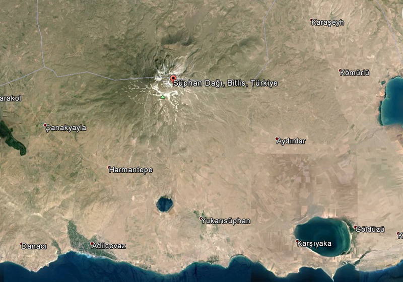
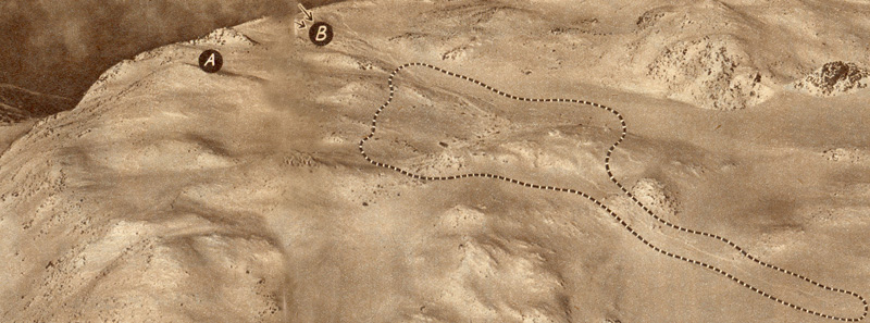
For climbing Mount Süphan, located within the borders of Adilcevaz district in Bitlis province north of Lake Van, the eastern or southern slopes are generally preferred. Our choice was the classic eastern route under the leadership of Adem Gül. We arrived at Kışkılı, connected to the town of Aydınlar, by minibus. The roadsides were covered with 1-2 meters of snow in some places. Out of habit, I called it a village, but you might be saying, “Is there any village left, brother?” and you’d be right. This is a neighborhood at an altitude of 2300 m—one of the highest settlements in Turkey.
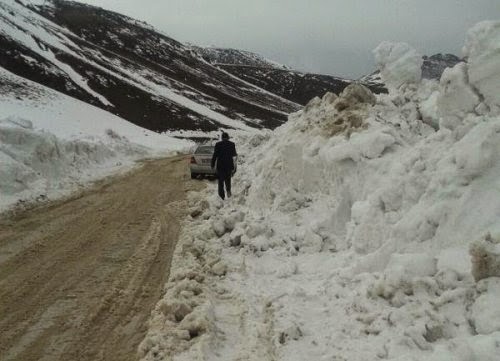
We had to keep the skidding minibus on the road by pushing it with a few people, but the road wasn’t completely blocked. We later learned that the municipality spends its limited resources on snow removal for six months of the year to keep this road open. It’s an admirable effort. May God give them strength; it’s hard work.
When we reached Kışkılı, we were greeted by the bright smiles of children leaving school. Maybe it was just the joy of finishing school, I don’t know. After greeting these little friends, who were extremely friendly towards strangers, we finished our preparations and set off with our camp gear. After a walk of about 2 hours with heavy packs, we reached the campsite at 2700 meters called At Yaylası (Horse Plateau).
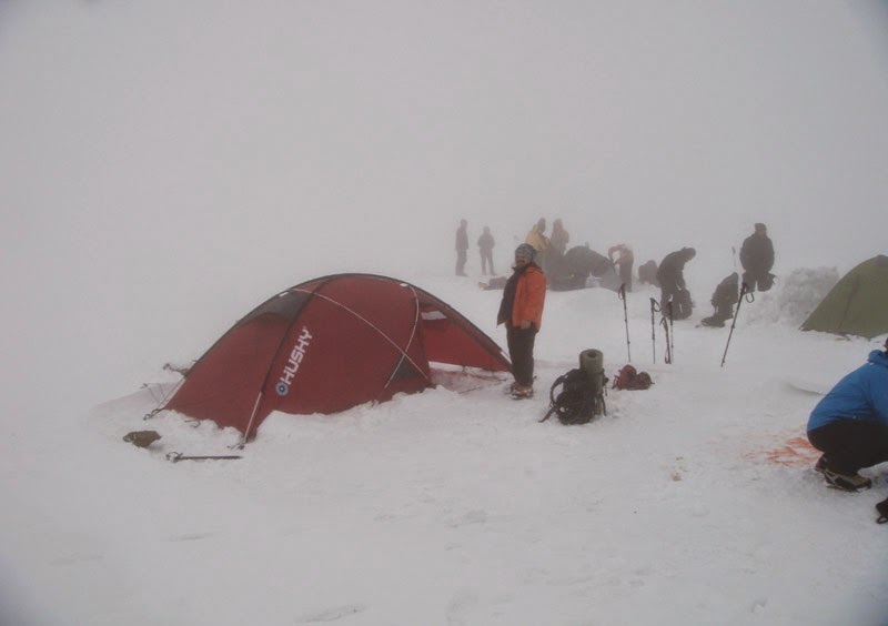
Our strategy for the Süphan climb was to set up a single camp at 2700 meters and focus on a direct push to the summit, which meant an elevation gain of about 1300 meters. Normally, when the road is closed, two separate camps can be set up—one at Kışkılı and then at “Ayna Altı” at 3100 meters—but we preferred to move with the speed of a single camp.
When we settled in our tents to rest, I learned an important lesson about mountain nutrition. The sandwiches I brought with roasted meat and green olive paste began to emit such a strange smell in the freezing cold that I completely lost my appetite. I experienced firsthand the importance of carrying foods like dates or nuts that are both easy to eat and genuinely appetizing at high altitudes where appetite tends to drop.
The Water Issue on the Mountain: Why Isn’t Snow Water Enough?
However, there is an issue more critical than food for me: Water and mineral balance. It’s not always possible to find a water source on the mountain; we usually meet this need by melting snow. But snow water has a major deficiency beyond its bad taste: it does not contain the mineral salts like sodium, potassium, and magnesium that our bodies lose. When we drink melted snow, our cells aren’t truly satisfied no matter how much we consume, because that water hasn’t yet touched the soil to incorporate minerals.
To solve this, I’ve been researching electrolyte tablets for a while. These practical tablets are lightweight and turn snow water into a functional liquid. If you don’t have tablets, adding at least powdered drinks improves the taste and restores some of the elements the body needs.
During my research, I found powdered drinks like “Tang” or “Nazo,” as well as healthier electrolyte tablet products intended for runners that do not contain artificial sweeteners.
These electrolyte tablets, containing essentially sodium, potassium, and magnesium, are the most practical and economical way to replace minerals lost during exercise. Those famous blue-yellow sports drinks also do the same job; however, they contain unnecessary additives and preservatives, and they are not suitable for carrying in a backpack due to their volume and weight.
When I couldn’t find these tablets in Turkey, I decided to try my luck abroad. I found a UK-based site and ordered two boxes, paying 30 pounds including shipping. Normally I don’t shop from unknown sites, but this time I “took the plunge” out of necessity. A few hours later, despite showing as in stock, I received an “out of stock” message. From the moment I requested a refund, total silence began; for a month, I received neither a response nor a refund. I knew the British were reserved, but this was too much\! As a last resort, I started the credit card chargeback process.
After this misfortune, I weighed my options again. I was either going to get obsessive and produce my own mineral supplement by dissolving metal rods with an electrolysis kit at home, or I would keep researching. Luckily, my time was limited; I slowly put my high school chemistry book back on the shelf, gave up on looking for trouble, and focused on other ready-made alternatives on the market. And I found this product containing the minerals I was looking for: WUP Electrolyte Effervescent Tablet. Various alternatives can be found in places selling products for fitness or marathon runners.
Summit Day: The Harsh Face of the Wind
We set up our tents and settled in. After the dinner phase with my tentmate Hakan, we checked our bags one last time and fell asleep. The departure time was set for 04:30 AM, but perhaps due to excitement, the night felt quite long.
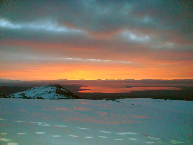
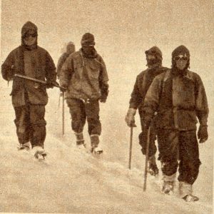
We got up around 04:00 AM and had a quick breakfast. When I grabbed my bag and rushed out, I realized no one else had left their tents yet and had to wait inside for a while. Packing up a large group of 22 people took longer than we expected; by the time we hit the trail, the sky had already started to lighten. Normally, I’m used to starting in pitch black with a headlamp, but this time it wasn’t necessary. Right at the beginning of the walk, we stopped to watch that unique sunrise gliding over Lake Van. Süphan definitely deserves to be a favorite of landscape-loving climbers with this visual feast.
From an altitude of 3100 meters, we hit that famous steep slope known as “Ayna” (The Mirror). Since the sky was clear, we passed this challenging stage reaching up to 3600 meters relatively easily. During the climb, we heard those characteristic sounds at several points signaling that the snow was settling; however, Adem Gül’s knowledge of the mountain and avalanche couloirs gave us peace of mind.
When we reached the final flat after 3800 meters, a completely different Süphan greeted us. The combination of fierce winds, the distance of the camp from the summit, and my own lack of training meant I began to push my physical limits. The performance of instructor Adem, who broke trail through the snow in front of us during the entire activity, was nothing short of admirable. He spent his energy to the last drop to carry 22 people safely toward the summit.
At 3900 meters, when we reached the crater slope of the mountain called the “külah” (the cone), weather conditions became very harsh. When the wind speed reached 60 kilometers per hour, the group split: one part wanted to try for the summit, while the other decided to descend. However, nature had the final word; as conditions became increasingly dangerous, the summit attempt was completely canceled, and we all began the return journey for safety reasons.
Checks I made on www.mountain-forecast.com before starting the climb clearly showed that the wind would exceed 50 km/h after 12:00 PM; indeed, the mountain did not disappoint. Let me describe the wind’s intensity: it was impossible to advance while standing without turning your body sideways to the wind. If you weren’t planted firmly and balanced, the gust was strong enough to hurl you a step to the side.
My biggest advice to those planning this route: if you are going to set up camp at 2700 meters, set out aiming to be at the summit by 11:00 AM at the latest. Adem Hodja had planned the movement for 04:30 to protect us from the freezing morning frost, but this caused us to reach the summit line at noon, when the wind was at its strongest. If we had set out just two hours earlier, the whole group would likely have summitted and returned safely. Even though the weather was harsh, thanks to our full winter mountaineering equipment, the cold didn’t shake us much. So much so that even the spare water in a PET bottle kept outside the thermos hadn’t frozen, which is not a common occurrence in winter activities.
Mystery on Süphan’s Summit: The 1959 British Plane Crash
Süphan’s fierce winds have a much more tragic counterpart in history. In 1959, a British plane crashed into the summit of Süphan, a victim of these very winds and freezing cold. Because cabin pressure was limited in aircraft of that era, they couldn’t fly very high. When the gauges froze from the cold and the storm diverted the plane from its route, the pilots failed to notice the mountain through the clouds and hit the summit. After the crash, the British formed a rescue team. They spent a great deal of effort both for rescue and to destroy classified information inside the plane. Events occurred that felt like a movie script.
It’s an interesting story; I’ve added it as additional info at the bottom of the page, I suggest you read it. You could even make a movie out of this story… It is possible to see traces of this crash during the climb. Debris parts can be found at certain points on the mountain. When we returned to Kışkılı, the weather was clear. The mineral pills had worked for me; I experienced no headache. The water in my thermos hadn’t run out. The Smiling Children of Kışkılı:
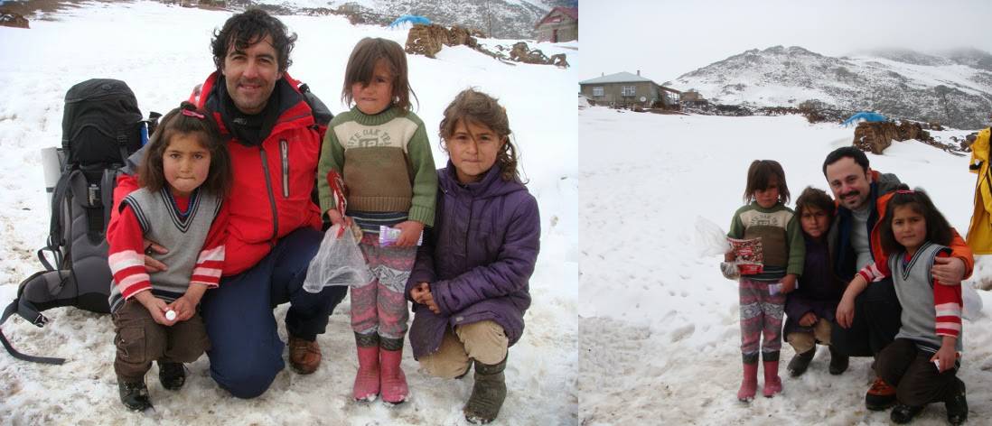
Passing through the village of Kışkılı, we encountered a group of children playing joyfully in front of their houses. With their curious looks and sincere smiles, they made us forget all the fatigue of the trip in an instant. To immortalize this beautiful moment, we came together with them and took a souvenir photo; the joy of Kışkılı filled our frame.
A Sweet Ending in Van
After a few hours of breathing in the atmosphere of Van one last time, we headed to the airport. We said goodbye to the whole team and returned to our homes in Istanbul on the evening flight. I would like to express my gratitude to all my teammates with whom I shared this journey, especially Faik Kayhan and Adem Gül, who put great effort into making this unforgettable activity happen.
Practical Advice for Climbing Mount Süphan
– Conditioning: Be accustomed to winter climbs with at least 1300-1400 meters of elevation gain.
– Equipment: Crampons, ice axe, and appropriate winter clothing are essential.
– Nutrition: If you are going to melt snow, definitely get electrolyte tablets or at least powdered drinks. Dates, nuts, and energy gels are lifesavers when your appetite drops.
– Timing: Aim to reach the summit by 11:00-12:00 AM at the latest. On Süphan, the weather can deteriorate very quickly in the afternoon.
– Weather Forecast: Be sure to check the wind speed via mountain-forecast.com a day before the climb.
– Guiding: Go with an experienced guide, especially in winter conditions. The presence of someone like Adem Gül who knows the mountain is vital for both your safety and motivation.
Mount Süphan offers an unforgettable experience with both its views and its difficulty. If you are considering climbing this peak, share your experiences or questions in the comments. Which route did you choose? What was the hardest part for you?
Update Note: This article is based on the climb in March 2015. Route conditions, equipment recommendations, and prices may have changed over time. I recommend checking the latest activity reports or local guides for up-to-date information.
Additional Information:
The Cold War had divided the world into two poles in the 1950s. Nuclear power was a very serious weapon for both sides. Not only the USA or the USSR, but many countries were working towards nuclear power. For this purpose, tests were being conducted secretly all over the world.
The British government decided to conduct nuclear tests in the late 1950s. These tests were to be carried out at a special center at the Woomera Base in Australia. The Woomera Base in South Australia was established in 1947, and a vast area was declared a “forbidden zone” for nuclear testing.
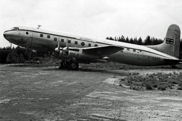
For the tests, the nuclear weapon was being transported by an aircraft leased from the British company Air Charter. The Avro-manufactured, four-engine Avro Super Trader IV type aircraft, registered as G-AGRH, was to embark on a long journey. In addition to the flight crew, British scientists were also on board.
The first leg of the flight, which began at night in England, was completed at Ankara Etimesgut Airport. After refueling here, the aircraft was to traverse eastern Turkey and proceed to Bahrain via Tehran.
On April 23, 1959, the aircraft radioed the Ankara Air Traffic Control Center, reporting that it was over Gemerek at 10:14 AM and then over Elazığ at 10:59 AM. This was followed by a communication over Muş at 11:26 AM. The last information received from the aircraft was at the Muş waypoint.
After that, no further word was heard from the aircraft registered as G-AGRH. Had the aircraft drifted north due to southern winds reaching speeds of 70 kilometers per hour, or had it perhaps made a forced landing in Russia? The situation was immediately reported from Ankara to England. The British, contacting Iran and then Bahrain, eventually accepted that the aircraft was missing. They requested the commencement of search and rescue operations.
Reconnaissance Flights Begin
Aircraft belonging to the Turkish Air Force were first dispatched to the region. The following day, search and rescue aircraft taking off from the British Air Base in Cyprus joined these efforts. Royal Air Force (RAF) aircraft were flying in the region with special permission from Turkey, searching for signals from the missing civilian cargo plane. However, dense clouds in the area were hindering the search efforts.
Six days had passed since the aircraft disappeared. On April 29, 1959, an RAF aircraft identified wreckage near the summit of Mount Süphan. Following this, Turkish Air Force RF-84F reconnaissance planes were sent to the area. Photographs taken established that the aircraft had crashed into the summit of Mount Süphan. It was immediately decided to dispatch search and rescue teams to the region.
Top Secret Weapons and Documents on Board
In the initial investigation conducted after the accident, considering the impact site, it was determined that the aircraft, following an instrument flight route, had been drifted north by strong winds, but this drift had not been detected by the flight crew. The Avro Super Trader IV did not have a cabin pressurization system. For this reason, the aircraft could not fly at very high altitudes.
During the flight, which was thought to have continued inside clouds, the pilots were expected to follow the route over the lake; however, the northward drift ended with the crash into the summit of the 4,058-meter-high Mount Süphan.
It was immediately decided to send the RAF Mountain Search and Rescue Team from near Nicosia, Cyprus. However, the team needed to reach the nearest airport. Since Van Airport did not have a runway sufficient for large aircraft to land at that time, the British arrived in Diyarbakır with special permission granted by the Turkish government. From there, they reached Van and then Adilcevaz by road.
Helicopter Support
You can read the memoirs of the RAF search and rescue team, as researched and brought to light by Osman Soysal in his articles, at the bottom of the text…
Search and rescue teams managed to reach the wreckage by land on April 30.
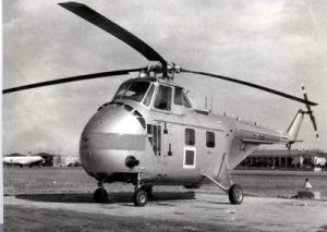
At such a high altitude, the helicopter could only reach the summit with a very light load. For this reason, the recovery of the bodies to the base could not be carried out. They were buried there. Top-secret weapon components were detonated by the RAF team.
Years later, local villagers took the remaining aircraft parts for scrap. However, interestingly, studies conducted in the region identified a significant increase in cancer cases following the accident.
RAF – Mountain Search and Rescue Team (RAFMRS-RAFMRA) Mount Süphan Rescue Operation (1959)
Translation: Osman SOYSAL
The RAF (Royal Air Force) Mountain Search and Rescue Team was established in 1954 in Nicosia, Cyprus. This team was formed to conduct search and rescue activities at high altitudes, and it carried out its first major operation in winter conditions at an altitude of 14,000 feet.
The team’s area of responsibility was limited to activities conducted by British and allied air forces in the Eastern Mediterranean. When a British aircraft went missing in eastern Turkey in April 1959, the team in Nicosia initially engaged in aerial search activities.
On Thursday, April 23, 1959, an AVRO TUDOR Supertrader IV (Zephyr) civilian cargo aircraft had already passed east of Ankara during the Ankara-Bahrain leg of its flight from England to the Woomera base in Australia. The aircraft carried 12 personnel and top-secret munitions for the Woomera Missile Base. During the flight, it was using the air corridor between Ankara and Tehran, which passes over Lake Van.
40 miles west of the lake lies the city of Muş. The Tudor sent its last signal to the air tower while over the city. While proceeding according to plan, an extraordinary development occurred seven minutes later.
After passing Muş, no sound or signal was received from the aircraft, and it was learned from Bahrain in the afternoon that the aircraft had not arrived there. Despite the Turkish Air Force’s aerial search for the missing Tudor the next day, the RAF Search and Rescue Coordination Center in Nicosia did not engage in any activity regarding this matter until the evening.
On April 25, before dawn, two Hastings and one Shackleton aircraft took off to search a 40-mile radius around the location of the incident within Turkish airspace. Necessary permissions were obtained for these aircraft to conduct aerial search activities in Turkey.
Turkish and Iranian aircraft also assisted in the search activities. The Mountain Search and Rescue Team was notified of the incident on April 25, but it took time for the team to assemble with their equipment at their main base in Kyrenia. They were ready at the Nicosia base by 10:00 AM on Saturday. It took an hour and a half for the team to prepare before sunrise, and they were ready within two hours. For the following four days, they waited for the aerial search activities to conclude. A para-medical rescue team was kept on standby.
A Team of 17 Goes to the Region
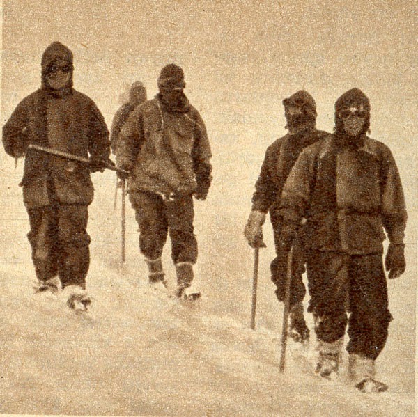
17 people from the mountain search and rescue team were kept ready to spring into action if needed. Although they did not have an officer at their head, Flight Lieutenant Robertson took responsibility. The Lieutenant had led the team several times during training sessions held on weekends. As soon as he arrived from the Middle East Air Force Command Headquarters in Episkopi, he asked for his crampons, which had been sent from London via Canberra Jet.
While waiting, the team continued their routine training. On April 26, they received information regarding the cargo on the Tudor aircraft. The search area covered a 25-mile expanse. Between April 25 and April 26, search conditions were poor. It was very cloudy, and the peaks of the mountains were covered in snow. The RAF scanned a 50-mile area, but the Tudor was not found.
On April 29, despite the cancellation of the search, one of the Hastings under the command of Flight Lieutenant Noble concentrated its research on the summit of Mount Süphan (at an altitude of 14,547 feet).
The wreckage of the Tudor lay scattered very close to the summit of the mountain. In less than four hours, the rescue team was transported to the region. They needed to reach the secret cargo, which was of vital importance to the RAF, as soon as possible.
Although the wreckage of the Tudor was found, there were no signs of life at the crash site, and after six nights spent at this altitude, hope for the crew had been lost. On the afternoon of April 29, the team arrived at the Diyarbakır Military Base in eastern Turkey, where they unloaded their Land Rovers from the plane and assembled them. (To load a Rover into a Hastings, the spare tire at the back, its mechanism, and the window must be removed). When the assembly of the vehicle was completed, another Hastings arrived in the region with a second Rover.
Discussions began with Turkish authorities regarding the provision of drivers for transport. Meanwhile, the main team was placed in a hotel to eat and rest. To reach Mount Süphan, the team set off in a convoy at 2:00 AM on the morning of April 30 from Diyarbakır, 160 miles away.
Besides the Land Rovers, the convoy included 15 trucks to carry equipment and two jeeps belonging to the Turkish Air Force. A Turkish liaison officer, an NCO specialist, and a deputy commander serving as an interpreter accompanied them to ensure communication.
During the night, the weather was very hot as they passed through valleys surrounded by mountains on both sides, and the journey was quite difficult. The team in the convoy had to choose between opening windows and being smothered in dust or staying in the heat without air. The road deteriorated significantly after 60 miles. With dawn, they reached a region surrounded by deep valleys with snow-capped mountains. When they first saw their target from a distance at a slightly higher elevation, they were still fifty miles from the scene.
Despite being far away, the mountain looked magnificent even from where they stood. Clouds surrounded the peak of Süphan, but they could easily discern the size and breadth of the massif below the summit. It looked like a dangerous and massive beast. They reached the village of Norşıncık on the northern shores of the lake at 4:30 PM in the afternoon. They had reached 2,000 meters, but they preferred to set up their main camp at a higher altitude.
However, after a reconnaissance, it was realized this would be impossible at that hour, and it was decided to house the entire team in the village primary school. A briefing was held in the evening. They learned that Mount Süphan has two peaks and that the Tudor wreckage was located on the eastern peak.
The crews of the aircraft that identified the wreckage explained that the easiest route would be to climb the western peak first and then easily cross to the eastern peak via a small ridge. The only map they could obtain consisted of 16,000-scale aviation diagrams. The aircraft performing the search discovered that there were mountains in the region not included on their maps.
Ascent to the Summit
It was decided that four people, each an expert in their field, would carry out the search activity at the summit. Although the chance of finding survivors in the wreckage was low, this option was included in the probability calculations. In addition to this team that would climb to the summit, it was decided to form another nine-person team to provide logistical support such as food and transport. The designated members for the lead team were Jack Emmerson, who had mountaineering experience, and Whelan, Bottomer, and Costall, who were experts in aircraft, instruments, and radio. The entire team was experienced in mountaineering.
They woke up very early in the morning and set off at the first light of the next day (May 1). Using vehicles as far as they could go, they saved themselves from walking two miles. When the slope began to increase, the difficult part of the task began. Emmerson chose the south-southwest ridge where the slope was most suitable. Although the rest of the team was only responsible for carrying loads, the four climbers still had thirty kilograms of personal equipment and flares per person.
They ascended rapidly until they reached the snow line. Although they initially encountered hard snow, the situation quickly worsened: under their feet was a thin layer of ice that broke with every step, covered with slushy snow underneath. A helicopter took off from the main camp, descended over them, and dropped the latest photographs of the wreckage. However, these were not very useful as they consisted only of simple mountain scenery.
Above 9,000 feet, they were now constantly moving within clouds, and the snow covering the ground had deepened. The slope increased, the clouds thickened, and the wind intensified; this was followed by heavy snowfall.
Towards noon, the load carriers became exhausted, and considering the time elapsed, it was decided to set up the first camp at 11,000 feet. The load carriers unpacked two tents and began setting them up in an area with a small natural shelter slightly below the ridge. However, despite everything, it was quite windy. After the tents were set up, the carriers left the four mountaineers at the first camp and returned to the main camp. The climbers cooked and ate on their Primus stoves and established radio contact with the main camp. This was the last time they used the radio, as the radio batteries later froze completely due to the cold. Before dark, the cloud mass covering the mountain dispersed, and the main camp became visible from above.
A Cold Night
The night was very long and cold. Those who did not have sleeping bags were very cold. Heavy snowfall continued throughout the night. The next morning there was a clear sky, brilliant sun, and a cold, light breeze. Since a large portion of the tents were buried in snow, they could only move with a slight delay. Emmerson split the group in two. While he moved with Costall, the others followed from behind. They split the food and left part of it in the tent at the first camp. They continued walking in deep snow toward the top of the ridge.
It was a morning with a clear sky, and they were advancing slowly in an environment on the mountain that was not entirely unfamiliar to them. In the northeast, other mountains were visible shining brightly in the distance. These could perhaps be Ararat or other mountains belonging to Armenia in the distance. They had previously planned for a Hastings to fly low near the wreckage, and when they were about 200 feet below the summit, they saw it making a turn in the south-west direction. Clouds were continuing to build up. This explained why the aircraft descended without signaling. Seeing the Hastings drop metal boxes, they realized the aircraft was trying to mark the location of the wreckage, which the ridge they were climbing prevented them from seeing.
At 11:00 AM, they reached the western summit (14,547 feet) and realized that the actual caldera was only about two miles away on the opposite side, and there was a depression of about 1000 feet between them that they had to cross. From the western summit, they reached a wide plateau covered with stones, which was entirely cleared of snow in some places due to the effect of the strong wind. They crossed this depression laterally and reached the base of the slope leading to the final section. It was here that they decided to set up the second camp, and while Costall searched for suitable ground for the camp, the others went to get the supplies from the previous camp.
The Other Team Arrived by Helicopter
When they reached the slope of the western peak, they noticed four people above. These were Flight Sergeant Robertson, medical officer Ellis, and the other two members of the team, Bishop and Murphy. Since the eastern summit was covered in clouds, they had been taken by helicopter up to the western summit at an altitude of 11,000 feet.
This second team, which descended to the plateau, had no sleeping bags, no tents, no stoves, and no food. While climbing the last part, they had now become a team of eight people in total with food and tents for two. Everyone except Murphy and Bishop was tired and seemed affected by the high altitude. It was necessary to find a second tent for the second camp.
Robertson thought the Hastings had dropped tents at the summit, but it was impossible to find these metal crates within the clouds covering the peak. Thus, Emmerson, Bottomer, and Whelan continued to the first camp.
They managed to bypass the western summit from the south-southwest slope. While dismantling the tent at Camp 1, Bottomer and Whelan descended to the Main Camp. Emerson carried the tent, food, and stove to Camp 2. Despite climbing very slowly, his strength was exhausted before he even reached the plateau. Meanwhile, Murphy and the chaplain tried to reach the wreckage and find the metal boxes containing the other tents.
Even though they were very close to the wreckage and even smelled the scent of a fire that had been lit previously, it was not possible to find either the wreckage or the metal boxes within the dense cloud. they had found rock fragments lying randomly on the caldera, but they were not positioned in a way to form an effective shelter.
Six people stayed in the tents of Camp 2 for the night. They woke up early. Emmerson was sick. One of the chaplain’s thumbs had become infected. This was enough to make everyone feel nauseous. If it were up to the chaplain, he would have continued the summit climb, but the doctor did not allow it.
Emmerson had pushed his body too hard the previous day and was very tired. If it were up to the chaplain, he would have succeeded in reaching the summit, but the doctor forbade him. The other four people climbed the remaining eight hundred feet in two hours to reach the summit.
Above the large boulders, there was a rocky plain covered in snow. When they reached the top, the wreckage lay scattered on the slope of a parasitic cone located to the east of the caldera. There were no survivors. The doctor said they all lost their lives as soon as the plane hit the ground. They buried the bodies as best they could, and Murphy read a short prayer for the souls of the deceased.
They smashed some of the secret equipment into pieces with their axes. At noon, they descended to Camp 2 and picked up Emmerson and the chaplain. They detonated a green flare on the ridge at an altitude of 9,000 feet. By a great coincidence, the signal was noticed by a villager. The situation was correctly interpreted as a request for a helicopter, and a helicopter picked them up from the ridge and brought them safely back to the village.
The day after, the demolition expert Team Leader Ellery, who had bombs with him for use at the summit, arrived in Norşıncık. He and the other members of the team were to be transported by helicopter to the highest possible point, and from there, they would reach the point where the wreckage was located and systematically destroy it. However, Ellery had no previous mountaineering experience.
On May 2, with the help of clear weather, one of the helicopter pilots discovered a better route extending to the northern part of the mountain. And Ellery, Bottomer, Whelan, and Sergeant Appleby were transported by helicopter to a 10,500-foot-high section of this north-eastern ridge. However, despite a grueling two-hour climb, they had not yet reached the summit. They decided to turn back. Unfortunately, they were now on the opposite side of the mountain, and it took them a total of two days to reach the main camp.
In the meantime, anticipating that the team would not be able to reach the summit, Robertson ensured that the other six members of the team moved toward the summit, again for destruction purposes. The helicopter managed to land this six-person group at a different point from the ridge where Ellery and his team had been dropped, also on the north side of the mountain. Helicopters could only carry one personnel to this point. It had to go back and forth every time.
Explosives Are Prepared
The other five men were lowered another thousand feet due to difficulties. The six-person team met and went directly to Camp 3 at the summit and settled into the tents found in the metal crates dropped by the Hastings two days earlier. The explosives could only be delivered the next day by a Hastings that found a gap between the clouds and dropped three crates.
While four members of the team collected papers and documents scattered from the wreckage, Murphy and Hercod, who had no previous experience in demolition, carefully read the destruction instructions. On the first attempt, one of the detonators did not explode, and Hercod, without fear and with great courage, replaced it with another. This brave act would lead to him being rewarded by the Queen.
They had to work inside clouds and mist throughout the day. The weather began to deteriorate further. These unfamiliar conditions caused Hercod and Murphy to become very tired. After finishing their work, they spent the night at the summit and began descending the south-southwest slope under heavy snowfall the next morning. For a while, they had to build a snow shelter and take refuge in it. They waited for the weather to improve under difficult conditions inside the shelter for a long time. Those at the main camp, who were constantly watching and alert, noticed the flares fired by those above, and as the weather calmed, a helicopter took off, picked them up from above, and brought them down. The following night, the entire team arrived in Nicosia.
Sources: Osman Soysal’s website: http://www.osmansoysal.com/yazilarim/muhtelif/68-suephan-daina-dueen-nglz-ucai.html